Walks around the Val de Tamié
A few examples :
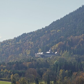
The Val de Tamié site is remarkable for its Cistercian abbey nestling on the slopes of the Tête Noire, and its former military fort. The walk takes place in the valley. It starts from the abbey car park, climbs steeply, descends through undergrowth, visits the Fort de Tamié, offers a magnificent view of Mont Blanc from the Collet de Tamié, and then descends to the Moulin de Tamié.
-
Distance : 6,99 km
-
Average duration : 2h 50
-
Difficulty : Easy
-
Return to start: Yes
-
Elevation gain: + 300 m
-
Negative gradient : - 303 m
-
High point : 1 047 m
-
Low point : 841 m
-
Departure/Arrival: N 45.682712° / E 6.304721°
-
Carte(s) IGN : Ref. 3432ET, 3432OT, 3432OTR
L'Abbaye de Tamié à partir des Combes
A pleasant walk through pastures, riverside and forest to reach Tamié Abbey, nestling at the foot of the Bauges massif.
-
Distance : 9,57 km
-
Average duration : 3h 25
-
Difficulty : Medium
-
Back to the start : Yes
-
Elevation gain : + 236 m
-
Negative gradient: - 241 m
-
High point : 908 m
-
Low point : 760 m
-
Departure/Arrival : N 45.713304° / E 6.315843°
-
Carte(s) IGN : Ref. 3432ET, 3432OT, 3432OTR
A short family hike and a visit to Fort de Tamié. Within the walls of the fort, there are tree climbing courses, games for children and walks for all, not forgetting the superb views over Albertville. Rather than taking the car to get to the fort, it's very pleasant to go on foot.
Distance : 2,71 km
-
Average duration : 1h 10
-
Difficulty : Easy
-
Return to start: Yes
-
Elevation gain : + 127 m
-
Negative gradient : - 126 m
-
High point : 990 m
-
Low point : 881 m
-
Departure/Arrival : N 45.673244° / E 6.308573°
-
Carte(s) IGN : Ref. 3432ET
Balade dans les crêts de Seythenex
Documentation can be collected from reception atl'Hostel des Combes au Val de Tamié
-
Distance : 2,700 km
-
Average duration : 1h 00
-
Difficulty : Easy
Discover the 6 places indicated on the map provided by Val de Tamié.
Nearly six kilometres of ridge in total! A few vertical sections, around twenty sections secured by cables and, to spice things up, a few aerial sections. A majestic environment, an imposing panorama. A very pretty hike, undoubtedly exceptional, but well worth the effort. Be warned: this hike requires some mountain experience. It should be undertaken in very good weather conditions, on dry, windless ground. The climb is mainly through forest, while the ridge line is virtually treeless.
Warning, very difficult route
This route requires a long and/or intense physical effort, either because of a very significant difference in altitude or distance, or both. In certain situations, there is also the possibility of technical and aerial sections..
-
Distance : 13,16 km
-
Average duration : 7h 35
-
Difficulty : Very Difficult
-
Return to start: Yes
-
Elevation gain : + 1 344 m
-
Negative gradient : - 1 336 m
-
High point : 2 044 m
-
Low point : 847 m
-
Departure/Arrival : N 45.713141° / E 6.316052°
-
Carte(s) IGN : Ref. 3432ET, 3531OT, 3531OTR
Discover the Tamié valley and the famous Seythenex bridge in a calm, bucolic setting.
-
Distance : 8,21 km
-
Average duration : 3h 05
-
Difficulty : Medium
-
Return to start: Yes
-
Elevation gain : + 244 m
-
Negative gradient : - 236 m
-
High point : 875 m
-
Low point : 658 m
-
Departure/Arrival : N 45.713374° / E 6.315799°
-
Carte(s) IGN : Ref. 3432ET, 3432OT, 3432OTR
Circuit de la belle Étoile et de la Négresse / Roc Rouge
A lovely hike on the border between Savoie and Haute-Savoie, on Albertville's iconic peaks of La Belle Étoile and La Négresse.
The backdrop is the Bauges massif, the Beaufortain, the Lauzière, Mont Blanc and the L ac d'Annecy.
A hike to be enjoyed in dry weather, with aerial passages and equipped with ladders and handrails.
Distance : 9,07 km
-
Average duration : 5h 15
-
Difficulty : Difficult
-
Return to start: Yes
-
Elevation gain : + 928 m
-
Negative gradient: - 923 m
-
High point: 1 827 m
-
Low point : 1 070 m
-
Departure/Arrival : N 45.682129° / E 6.318324°
-
Carte(s) IGN : Ref. 3432ET, 3531OT, 3531OTR
Pointe de Chaurionde depuis l'Abbaye de Tamié
A beautiful walk in the Bauges massif, with magnificent 360° views of Lake Annecy, Mont Blanc and the Bauges mountains such as L'Arcalod, La Sambuy, etc...
-
Distance : 18,68 km
-
Average duration : 10h 15
-
Difficulty : Difficult
-
Return to start: Yes
-
Elevation gain : + 1 733 m
-
Negative gradient : - 1 731 m
-
High point : 2 144 m
-
Low point : 891 m
-
Departure/Arrival : N 45.689225° / E 6.302669°
-
Carte(s) IGN : Ref. 3432ET, 3432OT, 3432OTR